 (size
: 529kb)
(size
: 529kb)Geological background
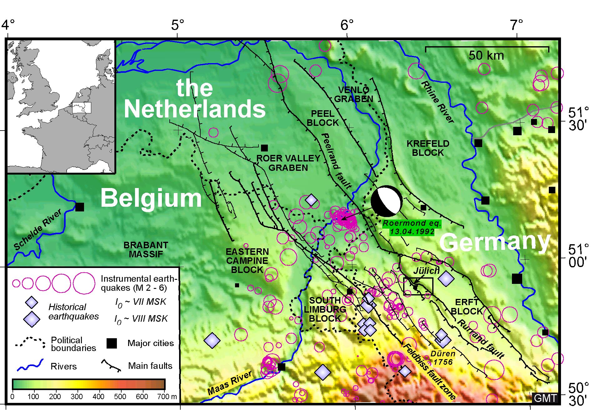
Since 1996, the Royal Observatory of Belgium is investigating active faulting in the area of the Lower Rhine graben system, an active rift system straddling the border region of Belgium, Germany and the Netherlands (Fig. 2).
(size
: 529kb)
Fig. 2 – Seismotectonic map of the Lower Rhine graben system in the border area of Belgium, Germany and the Netherlands.
In previous years, partly within the framework of the EC-project PALEOSIS , we mainly focused our work on the Bree fault scarp in NE Belgium. This fault scarp is particularly well expressed in the morphology, and corresponds to a 10-km-long segment of the Feldbiss fault zone, the SW border fault of the Roer Valley graben, the central graben of the Lower Rhine graben system (Fig. 3). Using a combination of geomorphologic analysis, geophysical prospecting techniques and trenching it was established that the Bree fault scarp is the expression of an active fault that experienced several surface-rupturing earthquakes during the past 100,000 years, the most recent event during the Holocene (Camelbeeck & Meghraoui, 1998; Meghraoui et al., 2000; Vanneste et al., 2001). The present-day seismicity on the Feldbiss fault zone is very limited. The large (MS 5.3) Roermond earthquake in 1992 occurred on the Peelrand fault, the NE border fault of the Roer Valley graben in the Netherlands. In 2001, several small (M < 3) earthquakes were recorded on some smaller branches of the Feldbiss fault zone in the Netherlands. Large historical earthquakes are only known in the German part of the graben.
 (size:
120kb)
(size:
120kb)
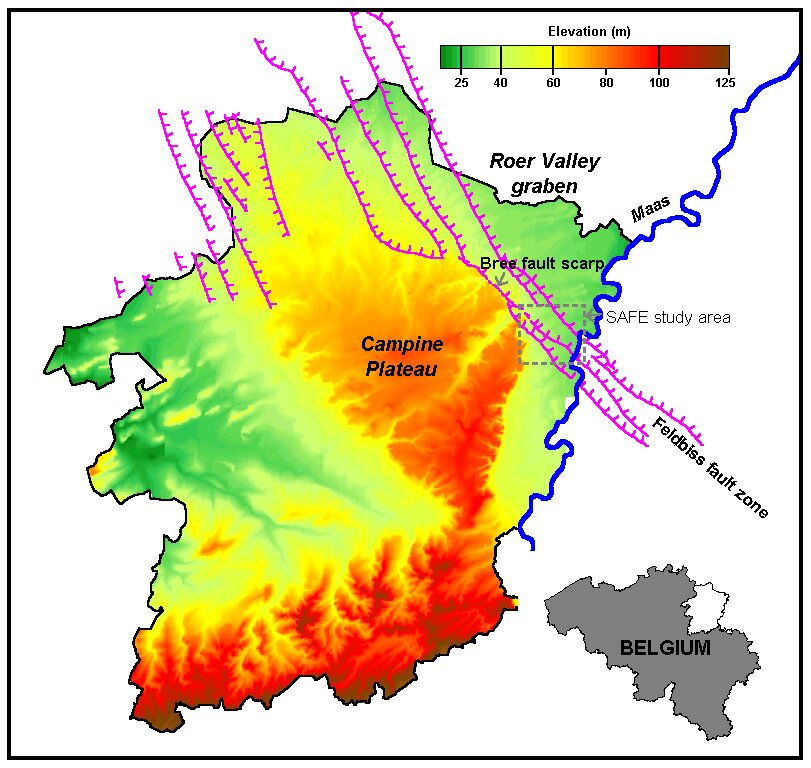
Fig. 3 – Elevation map of NE Belgium showing SW border faults of the Roer Valley graben, and location of the SAFE study area with respect to the Bree fault scarp.
Our contribution to the new EC-project SAFE ("Slow Active Faults in Europe"), which started in 2000, is aimed at the SE-ward extension of the Bree fault scarp in the Belgian Maas valley (Fig. 3). Between the villages of Neeroeteren and Bichterweert, the Feldbiss fault zone transects the younger terraces of the Maas river, covered by late Weichselian coversands, and the Holocene alluvium, joining with the Geleen and Feldbiss faults in the Netherlands (Fig. 4). The geomorphic expression of these fault segments is much reduced compared to the Bree fault scarp. Considering the low slip rates of these faults (< 0.1 mm/yr.), it is clear that the fault scarp morphology in the Maas valley does generally not exceed that of other landforms such as land dunes, small local drainage features, terrace scarps, and artificial landforms. It is therefore difficult to determine the precise location of these faults, and thus also to evaluate their activity.
 (size:
319kb)
(size:
319kb)
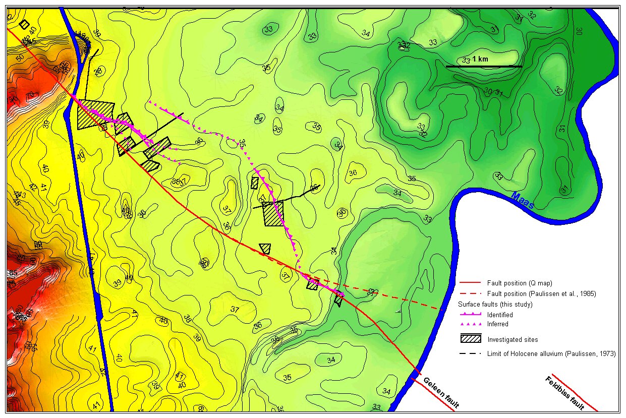
Fig. 4 – Elevation map of the Maas valley between the villages of Neeroeteren (in the NW) and Bichterweert (in the SE). From W to E, the Feldbiss fault zone consists of the Heerlerheide fault, the Geleen fault and the Feldbiss fault. The Geleen fault is generally considered the most active fault. The Heerlerheide fault is so far poorly investigated, although it has clearly controlled the limits of the Saalian and Weichselian Maas terraces, and of some incisions in the Holocene alluvial plain.