Aim
The EPOS-BE project is a four year BELSPO-funded project (project nr: FSIRI/33/EP1) and was created as Belgium’s contribution to the European Plate Observing System (EPOS). Under this umbrella, the projected long-term plan aims to combine forces of various research infrastructures of different Earth Science institutes from all over Europe. The idea is to unify data products and combine data infrastructures, enabling much faster and easier multilateral data exchange. One of the goals of the Royal Observatory of Belgium is to contribute to EPOS as a GNSS and seismic data provider.
Seismological part of EPOS-BE
In the first stage of the EPOS-BE project, six stations of the Belgian permanent Seismic Network are upgraded to increase high-quality seismic data of the Belgian Network to ORFEUS. The previous short period sensors (some even had only one component) are replaced by broadband sensors. If possible, we install borehole instruments down to 300 m, which will enhance the data quality by many orders as unwanted noise sources from mainly human influence (anthropogenic ambient noise) are suppressed. The monitoring task of the Royal Observatory of Belgium will profit from this a lot, providing state-of-the-art data quality and guarantee that the Seismology-Gravimetry section of the ROB will be able to fulfill their federal missions adequately in future decades.In the second stage of EPOS-BE, site-characterization studies will be performed for the newly equipped seismic stations and for the other seismic stations within the Belgian seismic network. Site-characterization describes the analysis of the shallow subsurface underneath a seismic sensor or location of interest. This is not only important for seismologists to understand what a seismic sensor is actually recording and if the geology of the shallow subsurface is damping or amplifying seismic waves, but also for civil engineers, who need these observations to estimate actual shaking of buildings or fragile infrastructure they are planning.
Site characterisation
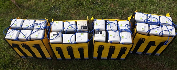
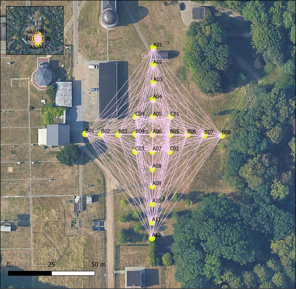
To fulfill the task, a holistic approach is used to integrate and combine many geoscientific data sources. All available information from previous geological and geophysical surveys are collected to understand the local subsurface. This also includes invasive methods such as boreholes or water depth measurements. The main task within EPOS-BE incorporates seismological field studies using passive array-methods of ambient noise sources. The technique is comparable with the concept of directional microphones. But here we do not use a specific sound source. Instead, the randomly distributed noise sources of the environment, e.g., wind, ocean waves hitting the coast, anthropogenic sources from traffic, infrastructure or construction (also see the seismic noise reduction in Uccle and observed worldwide during the Covid-19 lockdown), provide enough seismic energy. For the EPOS-BE project we purchased 24 new SmartSoloⓇ three-component sensors (Figure 1), in order to perform efficient field surveys. The lightweight, standalone sensors can be installed rapidly and record autonomously the ambient seismic noise for up to a month.The geometric arrangement of the sensors (see Figure 2) is key in array-seismology. The arrangement into special geometric figures depends on the seismic energy sources we want to use for the subsurface analysis, i.e., far-away and large magnitude earthquakes generate a directional wavefield of large amplitudes. For the site-characterization in the EPOS-BE project we rather use ambient noise sources, which are (theoretically) randomly distributed in direction and distance to the array and thus, we need to be sensitive for all azimuth-values. The size of the array, which is defined by intersensor distances and the aperture (the largest distance between two sensors), roughly correlates with the subsurface depth for which the array is the most sensitive (neglecting the subsurface lithology itself).
The processing of the recorded seismic waveforms is performed with the Geopsy software (link to the recent paper of Geopsy), a toolkit particularly developed for the analysis of ambient vibration recordings. In here, we use three different methods:
- H/V: is a single station method (based on Nakamura 1979) in which the noise spectrum (Fourier amplitude spectrum) ratio of the horizontal components to the vertical component is calculated. This gives an H/V peak amplitude for a specific frequency value (f0). From this we can estimate roughly the depth and strength of the impedance contrast as a result of changing the subsurface lithology from sediments to the bedrock.
- MSPAC (modified spatial autocorrelation technique): assumes that the recorded noise is the sum of seismic waves of randomly distributed sources, having the same phase velocity for each frequency. By fitting a spatial-correlation function of all station pairs in the Array to a theoretical curve, we derive implications for the subsurface s-wave velocities.
- Frequency-wavenumber (FK): here, the recorded noise at all stations of the array will be translated from the space and time domains into the wavenumber and frequency domains, as their spectral counterparts. From this, another dispersion curve can be extracted, giving the phase velocities as a function of frequency.
Results
The final velocity models (see figure 3) represent the layered structure underneath a station/ an array, where each layer consists of a different geological unit with unique corresponding seismic velocities. As the passive methods used for the estimation of models have non-unique solutions, the velocity structures and values possess a range of uncertainty (see the width of different values per layer in figure 3). Therefore, the final solution is just the most likely solution and image of the subsurface structure we can extract. Average values of certain parameters of interest for engineering purposes (e.g., vS30, f0) are further estimated and communicated to the central storage of the EPOS project called ORFEUS station book. In here, meta-information of all publicly available seismic stations in Europe are stored in this centralized platform, giving a unified overview of all necessary base information to the global seismological community.